

Resources
Utility Magazine: Embracing technology to safeguard citizens in extreme weather events
Resources
July 28, 2023
By Paul Roberts, Head of Corporate Affairs, SA Power Networks
In response to the devastating 2022–23 River Murray flooding crisis, SA Power Networks dramatically transformed its flood response with AI and LiDAR technology to assess network damage and risk through digital flood impact modelling.
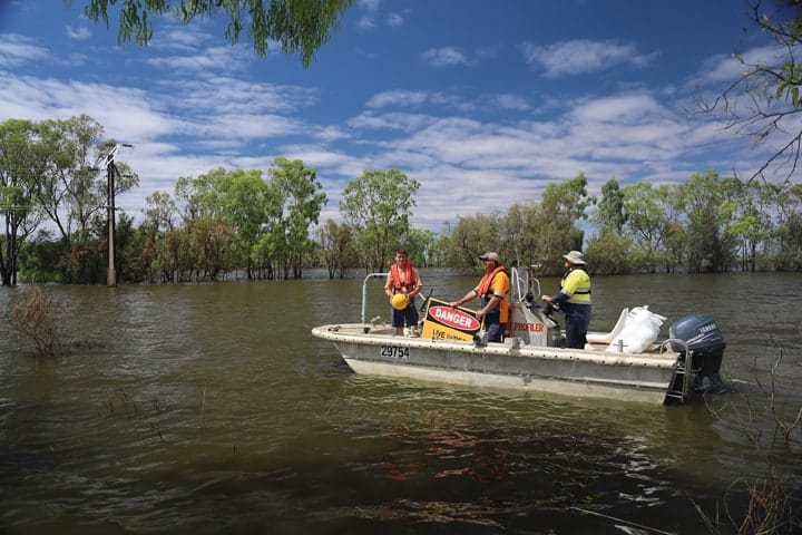
The recent River Murray flooding event was unprecedented in its magnitude, now declared South Australia’s most significant natural disaster. This status is not surprising given the extent of the flooding and its impact on the significant community living and working along the 650km stretch of the River Murray in South Australia. At its peak, River Murray floodwaters reached a level of 220 gigalitres, equivalent to the state’s entire reservoir storage running down the river each and every day. The subsequent damage from this event was widespread, impacting thousands of homes, businesses and people reliant on the river for their livelihoods.
As flood-level predictions escalated and the scale of the event became apparent, there was an urgent need for a new approach to managing the state’s critical infrastructure and electricity distribution network. As South Australia’s largest energy provider, the primary focus of SA Power Networks was to limit service disruptions to river communities while keeping citizens, emergency service providers and the workforce safe during the flooding disaster.
These two priorities were underlined by the overarching objective of conforming to legislated powerline clearance levels at all times throughout the flooding crisis while restoring power to customers as quickly as possible as the water receded. To meet these goals, a new approach underpinned by state-of-the-art technology was deployed to inform decision-making and accelerate response times.
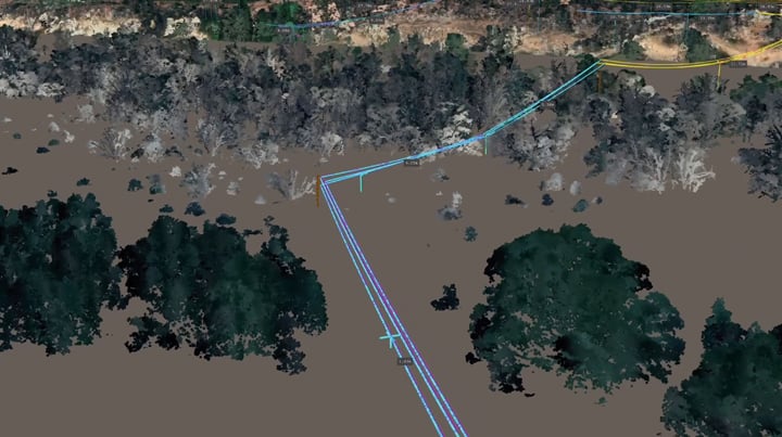
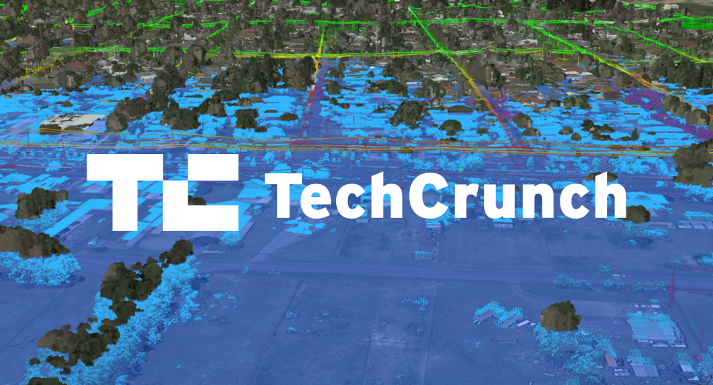
A sample 3D model produced by Neara.
Technology as the backbone of critical weather responses
Initially, SA Power Networks was forced to manage most of its response to the flooding event manually. Asset inspectors and field crews were sent to various locations to monitor the impact of water levels on safe powerline clearances and their encroachment on electricity assets.
With flood waters rising quickly and the scale of the event increased (3,300 customers were disconnected and 4,000 Stobie poles stood in floodwaters), the need for an innovative approach underpinned by technology became apparent. As a result, leading 3D modelling platform Neara was identified and launched.
Neara’s advanced artificial intelligence (AI) and LiDAR processing capabilities, an exercise that employs laser beams to measure distances and create 3D maps of the Earth’s surface and objects, were deployed to develop a comprehensive 3D map of the entire River Murray region including SA Power Networks electrical assets and the associated environment. This approach was significant in that it marked the first time SA Power Networks deployed LiDAR-related, AI-powered technologies in response to extreme weather-related events.
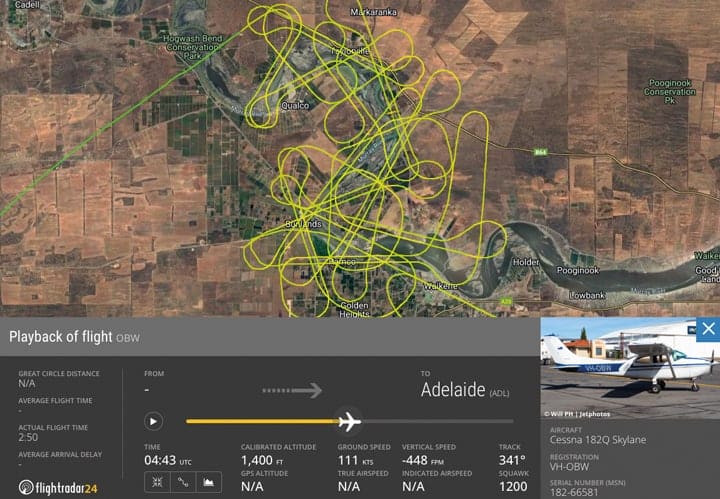
Over the course of five weeks beginning in early December 2022, a light aircraft flying at an altitude of 1,200 to 1,400 feet was employed to capture LiDAR data associated with SA Power Networks assets located within the flood area, with the main priorities to capture powerlines and attachment points. Throughout the month, trillions of LiDAR data points over the 650km River Murray region at a resolution of 20 points per square metre were collected. Neara’s technology then classified the LiDAR data including poles, conductors, buildings and terrain, and merged this information with additional data sources to create a sophisticated 3D model of the network.
Whether it was a pole or conductor, all assets were critical to building a digital model of the network that allowed the SA Power Networks team to model water levels both in real time and at the flow rates forecast by the government and meteorology experts. Flood water modelling proved to be the biggest challenge SA Power Networks’ teams had to solve, and the process behind these assessments needed to occur at scale every day as water levels shifted. Through AI-powered modelling capabilities, reports analysing 21,000 powerline spans within a 314GL per day flood area were completed in 15 minutes.
Without advanced AI and LiDAR capabilities, this process would have taken weeks if not months, to complete through manual business systems and resources. Without digital insights, greater areas of the network and a larger portion of citizens would have remained disconnected for extended periods.
Harnessing data for advanced decision-making and community safety
The challenge of wide-scale area analysis at speed was overcome through the sourcing of data from various sites, ranging from the Bureau of Meteorology and Murray Darling Basin Authority website, every five minutes for consistent updates.
Once this data was calibrated, the LiDAR data collected had a validated accuracy of 220 millimetres. Once measurements were refined with verified test cases, the complete River Murray 3D model allowed SA Power Networks to model the different impact scenarios on electricity distribution network assets at various flood levels, predicting where and when power lines may breach clearances or be inundated requiring electricity disconnection.
Through enhanced digital capabilities, customers along the River Murray were reconnected to electricity supply ahead of predicted timeframes. In some cases, regions were re-energised within five days compared to a projected three-week timeframe utilising traditional extreme weather event processes. This approach based on digital insights also played an essential role in helping keep the South Australian community, SA Power Networks team members and emergency service responders safe throughout the floods.
The sheer scale of the disaster spread across hundreds of kilometres of powerlines and electricity infrastructure, which were left standing in flood water for extended periods. Yet, not one electric shock was reported throughout the event. This was a direct result of decisive decision making. As floodwaters peaked, SA Power Networks was supported by digital network damage analysis and reporting. The ability to visually simulate how floodwater and infrastructure assets were behaving under flood conditions was critical in the decision-making process, with impacted or compromised lines depowered and those free to be reconnected re-energised in a much shorter time frame.
This approach not only stabilised the grid but the lives of local citizens reliant on consistent energy sources to navigate the challenging external environment and remain connected during the flooding event.
Collaboration and future preparedness
The River Murray flooding event provided incredible insight into the capabilities of technological innovation and how leveraging digital insights during these extreme weather scenarios can support efforts to keep residents connected and safe during high-risk circumstances.
Insights generated through the Neara-generated 3D model were extensive, going well beyond the existing network infrastructure. These insights not only played an essential role during the River Murray flooding event but have now been shared with various departments in the South Australian Government and emergency services to assist with the management of future extreme weather events.
SA Power Networks technology-informed approach to the flooding crisis marked a major step forward in extreme weather event response management. Now, with a completed analysis of the entire flood zone on hand, supporting LiDAR data points will be further assessed to determine how technology can be amplified in future extreme weather events ranging from floods, severe wind storms and bushfires.
The priority for this technology-informed approach is to ensure our response to any environmental challenge is underpinned by rapid analysis of network damage and risk that helps reduce the impact on customers.
Reach out. We’re very friendly.
Contact us to learn more, schedule a demo, inquire about a pilot project, or discuss other needs.