How to Minimize Flood Risk with an Organized Response Framework
A Primer on Flood Management for Utilities
As severe flood events become more frequent, utility companies must design proactive management plans that ensure reliable, safe service for all.
For decades, relying on traditional methods like outdated flood maps, on-the-ground surveys and reactive restoration seemed good enough. But the needs of communities have changed. Your community deserves better — and you simply can’t afford extended downtime when tools exist to mitigate it. The last thing you need is a groundswell of customer complaints and regulatory inquiries as you scramble to recover your network safely.
How to build a framework that enables an organized response
With the right technology and preparation, rewriting a dependable, three-prong flood response playbook is possible. This fortifies community resilience, minimizes infrastructure damage and increases strategic recoveries up to 10x faster than ever before.
Anticipate, prepare and respond with an engineering-grade 3D digital model of your network
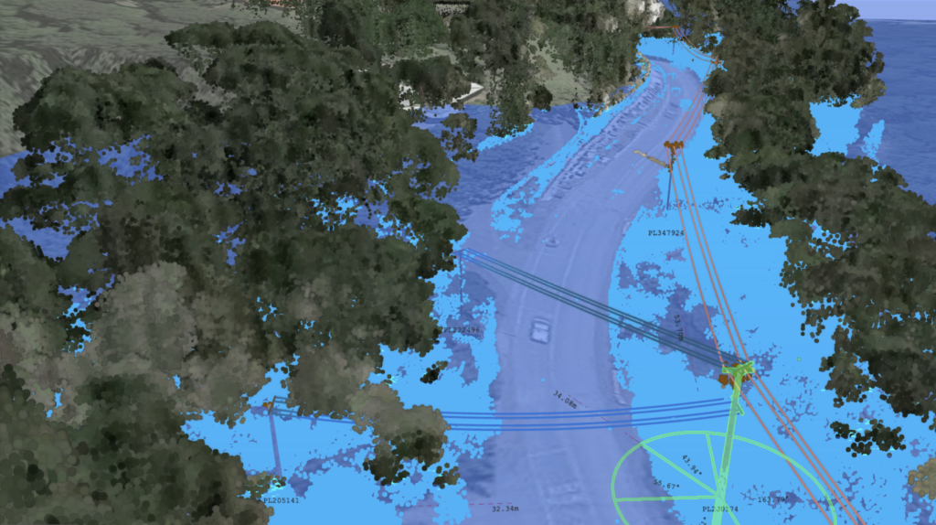
- 1. Simulate real-time flood conditions to assess vulnerabilities — Digital models built with your LiDAR, GIS and live weather data show you how various flooding conditions impact your network infrastructure — and reveal opportunities to harden your grid long before flooding strikes.
- 2. Design a data-driven power dispatch tailored to community needs — When will water come within three feet of our lowest line if 1.5” of rain falls per hour? How high can floodwaters rise before shutting off power around key aquaculture and mining operations? You can answer these exact questions in a 3D modeling platform.
- 3. Prioritize rapid power restoration and safe equipment repair — As floodwaters recede, your digital model will show you where to safely send your crews, avoiding risky on-the-ground inspections and slow, expensive aerial surveys.
By leveraging the right tools, it’s possible to deploy each phase simultaneously and consecutively. And at every stage, you can use the insights from your digital network model to keep all stakeholders informed, reinforcing your company’s credibility and authority.
Better flood management starts here
Simulate real-time flood conditions
The first step in developing your flood response program is proactive vulnerability assessment. The sooner you start, the better prepared you’ll be for your next flood event. In the past, you probably depended on broad strokes aerial or on-the-ground surveys to monitor for asset threats.
But these methods are vulnerable to human error. You need a more reliable information-gathering system for more informed decision-making.
Three layers worth exploring during your network assessment:
- 1. Vegetation — Excessive vegetation removal can accelerate downstream water speeds, but too little poses direct risks to your lines in extreme weather. Simulations help you target the most efficient vegetation management practices for your network.
- 2. Elevation geometry — It’s an oversimplification to just assume floodwaters rise and recede in a linear fashion. Understanding where and why flooding impacts your region will help you predict water behavior during and after major flood events.
- 3. Soil density — As seen during Hurricane Katrina, floods also occur when flood-control devices like levees break. By pairing water saturation with the soil density of such features within your grid, you can predict whether rivers will burst their banks and protect assets appropriately.
Build a more resilient network by identifying which assets to harden or replace
The promise of a proactive stance is often easier said than done — and requires fully understanding your network’s environment under changing flood conditions. With engineering-grade software like Neara, you can spot likely points of failure with 99% accuracy and home in on assets whose failure can trigger a cascade of other failures. That gives you the insights you need to start grid hardening weeks in advance — not in the shadow of a storm cloud.
Armed with your GIS and LiDAR data, insights from a 3D model help you prioritize what matters
Once you know how flood conditions can compound to threaten your assets, it’s time for grid hardening. Neara lets you overlay information like customer locations, transport corridors, land traversability and more to guide your decision-making. Your operational and field teams will have the data they need to prioritize which assets to harden and when, reducing overall risk of damage and downtime.
This may include:
- – Raising or relocating vulnerable equipment to minimize damage during flooding.
- – Upgrading critical power infrastructure like substations, transformers and power lines.
- – Fortifying vital facilities by installing flood barriers against rising water levels.
- – Identifying alternative access points for your team during restoration efforts.
And with this information in hand, you can start writing an actionable flood response plan with specific responsibilities and protocols tailored to your network.
Read more: How Neara Works
Strategic utility planning for a rapid flood response
Every utility wants to deliver rapid responses during flooding events. However, that’s easier said than done when you lack the right tools.
If you have one span affecting thousands of customers in Surrey, keeping power on for as long as possible is essential. Or, you may know that you’ll need to turn off certain feeders during major flooding events, but which ones and when? Such decisions become even harder when dependent critical infrastructure and industries may be unduly impacted.
Lessen impacts by focusing on where the risks are — or will be
Grid hardening efforts like raising or relocating poles are key, but they’re not enough. During a flood, you need to maintain situational awareness and find ways to share critical information across your organization to prioritize response initiatives and eliminate surprise hazards.
With Neara, your risk management teams can identify, quantify and prioritize risks at scale. Our fit-for-purpose platform enables:
- – Floodwater simulation with user-defined water depths applicable across your network.
- – Real-time data monitoring on water levels, rainfall intensity and vulnerable areas.
- – Output reports for flood water heights per pole and span-submersion events.
This helps your field and control teams maintain situational awareness and share critical information for an organized response. And your field and control teams can depend on this data for controlled, proactive shutdowns as conditions evolve.
A proactive shutdown approach facilitates:
- – Avoiding premature, widespread outages that leave communities in the dark.
- – Pre-emptive shutdowns of vulnerable facilities to protect equipment and personnel.
- – And as floodwaters recede, your team can conduct strategic, network-wide restoration diagnostics to identify damages and prioritize power restoration for your community.
This helps your field and control teams maintain situational awareness and share critical information for an organized response. And your field and control teams can depend on this data for controlled, proactive shutdowns as conditions evolve.

By monitoring water and clearance levels daily, SA Power Networks was able to leave power on for longer for many customers as the floodwaters rose and also restore power more quickly as water receded. This innovative approach allowed for the re-energisation of power lines within five days, compared with the originally anticipated three-week timeframe using traditional manual methods.

Doug Schmidt,
General Manager, Network Management
Tactical power restoration and asset repair
From efficient power restoration for customers to assessing to repairing damaged equipment, post-flood recovery only becomes more urgent and complex amid increasingly unpredictable weather. 3D simulation platforms like Neara can’t prevent worsening flood events — but they can enable better, more informed decision-making for the safest, most efficient response possible.
On the surface, your utility’s flood recovery plan is relatively simple:
- 1. Conduct damage assessments and safety checks of your network’s infrastructure.
- 2. Execute strategic restoration that returns power to critical public facilities and populations.
- 3. Establish transparent, regularly scheduled restoration updates for all stakeholders.
- 4. Collaborate with local authorities and relief organizations aiding affected communities.
- 5. Perform a post-flood analysis to improve your program and educate the public.
But this tidy checklist will always be complicated by the real-time conditions on the ground. For example, damage assessments are difficult when you don’t know whether water is ankle- or neck-deep in impacted areas of your network. In minor flood events, it’s easy to send a crew out for a quick visual check. But when widespread inundation affects thousands of spans, that approach becomes completely unscalable — and dangerous.
3D models mitigate these risks by helping you explore and process information digitally. In Neara, you can filter layers based on the network information that matters to you. And when it comes to damage assessments, you can do it all within the platform with 99% accuracy.
Strategic, efficient restorations for the most people possible
As floodwaters recede, restoring power to customers quickly and safely is your top priority. With Neara, you can strategically plan your efforts by identifying the most impactful equipment repairs. This prioritization allows your team to focus on critical infrastructure first, ensuring that as many customers as possible regain power in the shortest amount of time. And by applying your digital network model in this way, you’ll reduce downtime and the subsequent fallout from flooding, enhancing community resilience and trust.
- – Generate comprehensive summaries of affected assets to manage budgets effectively.
- – Filter data by clearance or the feature you care about most — then deploy crews accordingly.
Eliminate safety risks for the public and personnel
For your crews, restoration is the most dangerous part of any flood event. Your on-the-ground teams face the daunting task of repairing infrastructure under conditions that leave them vulnerable to electrocution. Meanwhile, your company must also manage the safety of the public and the overall integrity of your power distribution system.
Run simulations in Neara’s 3D digital model to identify post-flood safety issues like:
- – Submerged electrical hazards that increase the risk of electric shocks and electrocution.
- – Hidden hazards like submerged infrastructure and even sinkholes.
- – Utility poles and towers that may be compromised and vulnerable to collapse.
- – Waterborne contaminants such as pollutants or other hazardous substances that necessitate increased safety protocols and personal protective equipment (PPE).
- – Damaged roads, bridges and blocked routes that limit access — and alternative entry points.
Collaboration, cooperation and communication instill public trust
For many networks impacted by widespread flooding, recovery isn’t possible without support from other public utility districts. Your partners can rely on Neara, which serves as a single source of truth for all involved parties. This brings teams quickly up to speed on the nuances of your grid and your infrastructure, enabling faster, more efficient repairs.
But utility partners aren’t the only ones who can benefit from data gleaned in your 3D digital model. Your findings can and should be shared with local authorities and relief organizations providing assistance to those in need. By working together, community leaders can identify the most impacted areas and allocate resources effectively, streamlining the aid process.
Be transparent about your recovery plan
For those dependent on power, nothing is more frustrating than outages without a foreseeable resolution. Transparently communicating your recovery plan, and any scheduled rolling outages required to restore your network, helps manage public expectations. By proactively engaging with your customers, you’ll garner more support and goodwill. And through open communication, collaboration and sharing your knowledge, utility companies can build a safer and more resilient flood response for all.